Unless you've tuned out all forms of media, you likely know it's going to be quite cold for about 36 hours beginning very early Friday and continuing through midday Saturday. The reason why this cold has gotten a significant amount of press is because it is quite unusual and it's coming after a month where the temperature averaged 8 degrees above normal. To have such a dramatic change in a short period of time can be more impactful than if we had been cold all of January.
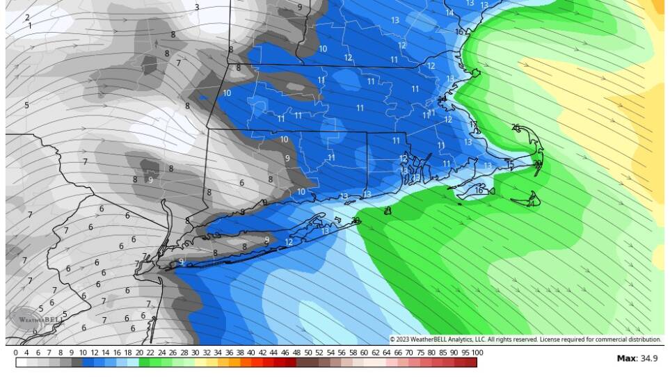
The demarcation of the true Arctic air is called an Arctic front. That will slip south across New England early Friday. It will be about 30 degrees around midnight, but fall toward 18 or 19 degrees by the time you get up Friday morning. Temperatures will continue their tumble and be at about 5 degrees by 7 p.m.


This air originated near Greenland. Due to the upper-level winds, a lobe of it will pass over New England Friday night and early Saturday. When compared to normal, some of the coldest air in the northern hemisphere will be over us during this time.
After the dramatic drop, the rise in temperature 36 hours later will be one of the biggest swings ever recorded.

On Saturday morning readings will be anywhere from 2 to 12 degrees below zero, with windchill readings from 15 to 30 below. If the temperature reaches 3 below at Logan Airport, which is entirely likely, a new record will be set. Remember that windchill numbers do not indicate a constant temperature; it will ebb and flow as the winds increase and decrease in gusts.
By mid- to late afternoon on Saturday, temperatures will be back into the teens and there will be less wind.
If you need to walk the dog or yourself, I would wait until 4 p.m. on Saturday and walk in that final hour before the sun goes down. This will be the most comfortable part of the daylight.

A southerly floor of air continues to boost temperatures slowly overnight, and by Sunday morning at sunrise, it's in the upper 20s. The afternoon will feature readings in the 40s — and that's where temperatures will be each afternoon for several days thereafter.

The cold is very quick. As long as your heat stays on, it's unlikely you'll have any issues with pipes. In terms of plants: If you're worried about a tender shrub or some early flowers which have emerged, you can always cover them with a sheet. But nothing is going to really be killed. There just might be some minor damage.