

As a major storm pummels the East Coast, communities across Massachusetts are preparing for the worst.
The storm is wreaking havoc from New Jersey to Maine, and high winds and flooding are affecting travel conditions, public transportation, and communities throughout the state.
Boston has reached its third highest tide — 14.67 feet — since records began in 1928, and the high tide tonight, which will hit around midnight, is expected to be even higher, according to the National Weather Service. As of early Friday afternoon, more than 700,000 electric customers were without power across the Northeast, with Massachusetts experiencing about 27,000 outages.
The National Weather Service says it was aware of hurricane-force wind gusts on Cape Cod, including one report of winds reaching 78 miles per hour in Wellfleet.
Governor Charlie Baker activated 200 National Guard members ahead of the storm.
In Boston, the weather has grounded flights at Logan. More than 350 flights had were canceled as of this morning. The storm is also taking its toll on the MBTA, which suspended ferry service today. The MBTA website also reports that the Atlantic Ave entrance to the Aquarium T station is closed due to flooding.
Amtrak has announced that it has suspended services between New York and Boston due to inclement weather until at least 6 p.m.

MassDOT has reported that nearly 300 snow crews are clearing roads in the west and central regions, and schools in several communities along the coast are canceled, including in Quincy, Rockport, Worcester, Duxbury, Marshfield, Hull, and Scituate.
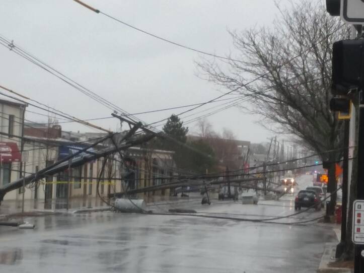
On Arsenal Street in Watertown, about five or six blocks have been closed because of downed power lines and utility poles.
On the northbound side of Route 140 along the Wrentham/Foxboro line, two trees are down. In neighboring Mansfield and Foxborough, hundreds have lost power.

Town officials in Scituate are urging residents to evacuate, as the coast is expected to be slammed with up to 3.5 feet of storm surge. Police have closed Front Street and flood waters are rising. An emergency shelter has opened up at Scituate High School, additional firefighters and officers are on staff today, and the town has also activated a dive team.

Scituate Town Administrator Jim Boudreau told WGBH News, “Once those tides come up we don’t anticipate being able to access those areas again until at least sometime on Saturday.”
High-tailed away from Front Street and Jericho Rd when Scituate Harbor water was getting closer and closer to my car! .@wgbhnews #noreaster boston #yesweather #stormy pic.twitter.com/WzeG3G7fqe— Marilyn Schairer (@mschairernews) March 2, 2018
Neponset Circle in Dorchester, where a motorist had to be rescued from flooding during last month's storm, has experienced some flooding, but light traffic was still making it through about noon. State Police did, however, close northbound lanes of Morrissey Blvd. at the on-ramp to I-93 north. Nearby Tenean Beach and its parking lot were flooded, and State Police blocked the street to access the area. There did not appear to be any major damage in the adjoining Port Norfolk neighborhood along the Neponset River estuary.
In Newburyport, the Merrimac River was churning with white caps, as wind from the Nor'easter hammered the river and its banks.

On Plum Island, a fragile 11-mile long barrier beach, waves have taken over the beach and are washing up over dunes and threatening houses. Officials in both Newbury and Newburyport warned homeowners to leave the area.
In Swampscott, waters rose high enough in a section of parking lot at Vinnin Square Plaza to cover nearly half of a sedan vehicle.

On Cape Cod, winds are expected to reach 75 miles per hour or higher, and many of the areas that were hardest hit by January’s storm are bracing to be hit hard again today. In Provincetown, residents have deployed sandbags around their homes and businesses to try to stop a repeat of the flooding in the last storm.

Sandwich officials say they’re concerned that some shore-front homes could end up in the sea after beaches there were weakened by the last big storm on Cape Cod.
This post has been updated.


