

Southern New England certainly hasn’t had a ton of snow this winter, and this follows the past few winters in which there has been less snow than average. The first week of February marks the anniversary of the Blizzard of ’78 which, for many remains the granddaddy of memorable storms.
Of course, with each passing year, there are fewer people who remember that big storm — and some who might wonder whether we’ll ever see something like that again.
The reality is that there will be another storm similar to the blizzard of 1978 at some point. Whether it will reach that level or exceed it is impossible to tell, but there will be another nor’easter that lingers off the coast like that, maybe even does a loop, and brings a couple of feet of snow and major coastal damage. It’s just a matter of time.
The blizzard of 1978 doesn’t even hold the record for the most amount of snow in a single storm anymore. That spot is held by the blizzard of 2003, also known as the Presidents Day storm of February 17-18, which brought 27.6 inches of snow to the city. The snow was much lighter and fluffier, there wasn’t quite as much wind, and tides never reached the level they did in the '70s blizzard. Nevertheless, the storm did cause a lot of cancellations and upended travel for a few days.
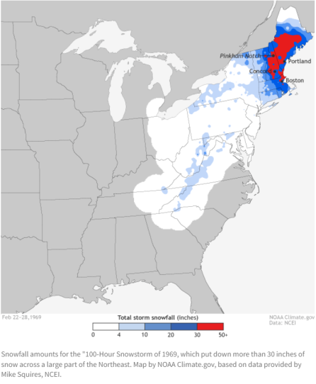
In terms of impactful snowstorms across New England, the most impactful was actually a storm that lasted 100 hours in 1969. On the Northeast Snowfall Impact Scale, a measure developed by Paul Kocin and Louis Uccellini of the National Weather Service which runs from 1 to 5, the 1969 storm was a 4 for the northeast corridor, but a 5 here in New England.
Winter snowstorms come in a variety of sizes and some certainly cause more problems than others. A heavy wet storm of 8 inches of snow can do a lot more damage than a light fluffy one with double that amount. A storm that comes during an astronomically high tide is much more detrimental to the coastline than, say, one that peaks during low tide.
Over the past several decades, as climate change continues to accelerate, the impact of these nor’easters on us here in the Northeast is changing.
Winter temperatures are warming quickly and we no longer see the same number of cold days as we did at the turn of the century. Take a look at the low temperature averages from the late 1800s to the early 1900s, compared to the late 1900s to the early 2000s. There are far fewer days below 20° than there was a century ago.

The lack of cold air can mean more storms with heavy wet snow — and thus more power issues. This can be especially true along the coastline, where the warmer water exacerbates the issue.
Storms can also create more coastal damage now than in the past. Maine experienced some severe coastal damage last month during a strong storm which occurred during an astronomically high tide. The highest sea level in Boston occurred back in 2013 during that nor’easter and exceeded the record set back in the blizzard of 1978. Each of those events had the odds of occurring once in a hundred years, even though they were spaced much closer.
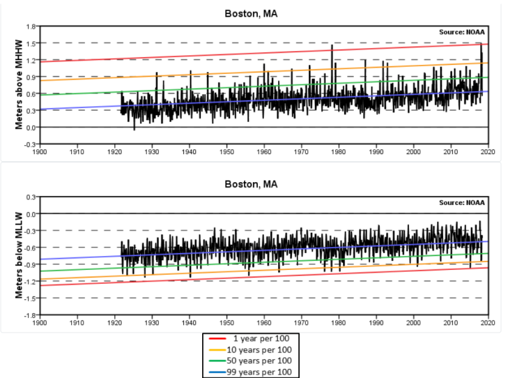
As sea levels continue to rise and water temperatures continue to warm, it makes it easier for a storm of similar size from 100 years ago to move more water inland today. Fifty years from now, the same storm that would occur this winter with the same tide would push even more water inland.

Winter is a highly variable season which can bring major snow, severe cold, but also unusually warm temperatures and heavy rain. Although the trend is for less cold over time, we still live in a part of the country where big snowstorms can occur accompanied by all the potential fallout from such events. Snowfall is likely to decrease over the coming decades, but storminess is forecast to continue or even grow in intensity.


